Vandenberg AFB, California · 22 February 1978 · Parkinson, Easton, Getting, West
America’s Gift to the World
The Pentagon put atomic clocks 12,550 miles up to guide its ships, planes and bombs. Then the United States opened the signal to everyone on Earth, free.

The moment · Labor Day weekend · 1973
A review board has just turned Brad Parkinson down. His plan, they say, is old work in new clothes. Over the holiday he pulls a dozen officers and engineers into the quiet Pentagon. Navy clocks. Air Force signals. A higher orbit. They come out with one design.
In 1973 the Navy and the Air Force were each building their own way to navigate by satellite. The Pentagon told an Air Force colonel named Brad Parkinson to build one system for every service. He took the best of each: Navy clocks, Air Force signals, orbits high enough to cover the planet. Twenty-two years later it was fully operational, and the whole world could use it.
Listening to Sputnik
The Soviet Union launches Sputnik on 4 October. Days later, at the Johns Hopkins Applied Physics Laboratory, physicists William Guier and George Weiffenbach record its radio beeps and measure how the pitch shifts as it passes overhead. From that Doppler shift alone, on a single pass, they work out its orbit. APL’s Frank McClure turns the idea around: if you know where the satellite is, the same shift tells you where you are.
The Navy navigates by satellite
APL builds the Transit system for the Navy’s Polaris missile submarines. The first prototype flies in September 1959. By the end of 1964 the lab has launched 15 navigation satellites, and Transit enters naval service. In 1967 Vice President Hubert Humphrey opens it to the ships and aircraft of every nation. Transit is slow and gives only latitude and longitude, but it proves that navigation from space works.
Clocks and codes
Two teams chase something better. At the Naval Research Laboratory, Roger Easton’s Timation program puts precise clocks in orbit, starting with a satellite launched on 31 May 1967. In Los Angeles, the Aerospace Corporation under Ivan Getting has studied navigation from space since 1963, work the Air Force names System 621B. In tests over White Sands in 1971 and 1972, 621B receivers fix aircraft positions to a hundredth of a mile, using transmitters on the ground and on balloons.
The lonely halls
In April the Pentagon puts the Air Force in charge of one joint program, under Col. Brad Parkinson. In August a review board turns him down: the plan is just 621B in new clothes. Over the holiday weekend Parkinson gathers about a dozen officers and engineers in the quiet Pentagon. The design that emerges takes 621B’s signal, the Navy’s atomic clocks and a higher orbit that circles the Earth twice a day. On 17 December the board approves it.
Navstar 1
An Atlas F, a retired intercontinental missile, lifts Navstar 1 into orbit, the first GPS satellite. It goes to work on 31 March. The Navy’s test satellites have already flown the first atomic clocks in space, starting in 1974. Rockwell International builds eleven Block I satellites, launched through 1985. Several outlast their three-year design life by more than ten years. Testers try the first receivers in the Arizona desert against ground transmitters standing in for satellites.
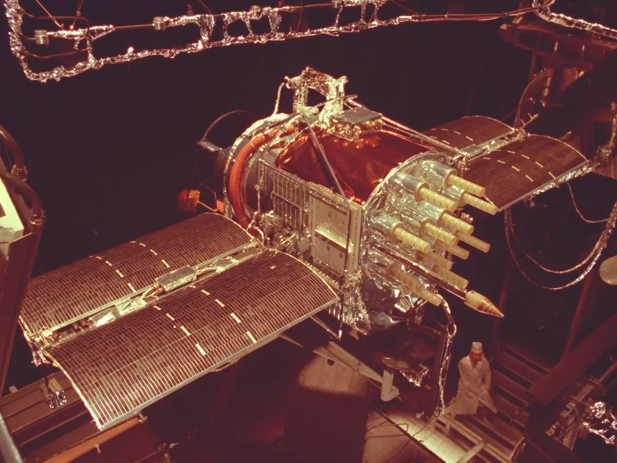
A full-scale GPS satellite in the Mark I space chamber at Arnold Engineering Development Center, Tennessee, in 1977, a year before the first launch.. U.S. Air Force / Arnold Engineering Development Complex. Einstein’s correction
GPS runs on time. Each satellite broadcasts the exact time from its atomic clocks, and a receiver turns the delay into distance. Here Einstein matters. Orbital speed slows the satellite clocks by about 7 microseconds a day. Weaker gravity speeds them up by about 45. Left alone, they would run 38 microseconds a day fast, and fixes would drift about six miles a day. So before launch each clock is set to tick at 10.22999999543 MHz instead of 10.23.
Open to every airliner
On 1 September a Soviet fighter shoots down Korean Air Lines Flight 007 after it strays over Soviet territory, killing all 269 people aboard. Two weeks later the White House announces President Reagan’s decision: when GPS is ready, the world’s civilian aircraft may use it. In 1991 the United States offers the civil signal to the whole world with no direct charge to users.
White House statement, 16 September 1983The President has determined that the United States is prepared to make available to civilian aircraft the facilities of its Global Positioning System when it becomes operational in 1988.
The first GPS war
Sixteen GPS satellites are working during the Gulf War, and the Pentagon has too few military receivers. It switches off the deliberate blurring of the civil signal and buys 10,000 commercial sets from Trimble and 3,000 from Magellan. Soldiers tape them to dashboards and helicopter panels. Tank columns cross a desert with few roads and few landmarks. Artillery hits its marks, and B-52 bombers and F-16 fighters navigate by satellite.
Ten times sharper
The constellation reaches 24 satellites in December 1993, and Air Force Space Command declares GPS fully operational on 17 July 1995. One limit remains. A feature called Selective Availability still blurs the free civil signal to about 100 meters. On President Clinton’s order, the blurring stops at midnight. Overnight, civilian receivers everywhere become up to ten times more accurate.
President Bill Clinton, 1 May 2000Civilian users of GPS will be able to pinpoint locations up to ten times more accurately than they do now.

The architects

Naval Academy class of 1957, commissioned in the Air Force. Flew more than 170 hours of combat missions in AC-130 gunships and earned the Bronze Star. As a colonel he led the 1973 design and ran the program through 1978. Later a Stanford professor.

Born in Vermont in 1921, joined the Naval Research Laboratory in 1943. Helped build the tracking system for Project Vanguard, then led Timation, which put precise clocks in orbit to find position by time. Awarded the National Medal of Technology for the work.

Born in Sutherland, Virginia, in 1930. Joined the Navy’s Dahlgren lab in 1956. From the 1970s into the 1980s she programmed computers to model the Earth’s exact shape from satellite data, work that helped lay the groundwork for GPS. Retired in 1998 after 42 years.
By the numbers
In pictures


Watch, listen, see
Films, photographs and first-hand accounts from across the web. Each opens in a new tab.

Brad Parkinson, GPS’s chief architect, tells how the system was born and what it now does for the world.
Stanford Online
An Air Force navigation officer explains how GPS works and why so much of modern life depends on it.
Smithsonian National Air and Space MuseumThe Naval Research Laboratory pioneer honored with the National Medal of Technology for the work behind GPS.
National Science and Technology Medals FoundationFrom a Virginia farm to the Navy’s Dahlgren lab to the Air Force Space and Missile Pioneers Hall of Fame.
Virginia Tech
The Smithsonian’s online exhibition on how clocks in orbit, from Transit to GPS, learned to find your position.
Smithsonian Time and NavigationParkinson’s 1999 oral history on the Labor Day weekend of 1973 and the fight to get GPS approved.
IEEE History Center
The 16 September 1983 White House statement offering GPS to the world’s civilian aircraft after KAL 007.
Ronald Reagan Presidential Library
President Clinton’s 1 May 2000 statement ordering full GPS accuracy for every civilian user on Earth.
Clinton White House Archives“Originally developed by the Department of Defense as a military system, GPS has become a global utility.”
President Bill Clinton, 1 May 2000
After
Parkinson and Getting shared the 2003 Charles Stark Draper Prize, one of engineering’s highest honors, for GPS. Easton received the National Medal of Technology and entered the National Inventors Hall of Fame in 2010. In 2018 the Air Force inducted Gladys West into its Space and Missile Pioneers Hall of Fame at a ceremony in the Pentagon.
Today the U.S. Space Force flies GPS from Schriever Space Force Base in Colorado. The United States commits to keeping at least 24 satellites working, and for more than a decade has flown about 31. A new generation, GPS III, began launching in 2018.
Airliners, ships, tractors and phones find their way by it. Cell networks, power grids and banks set their clocks by it. More than four billion people use it, and not one of them gets a bill from the country that built it.
Primary sources
- Scott Pace et al., The Global Positioning System: Assessing National Policies, Appendix B, “GPS History, Chronology, and Budgets.” RAND, MR-614, 1995.
- Statement by Deputy Press Secretary Speakes on the Soviet Attack on a Korean Civilian Airliner, 16 September 1983. Ronald Reagan Presidential Library.
- Statement by the President Regarding the United States’ Decision to Stop Degrading Global Positioning System Accuracy, 1 May 2000. The White House.